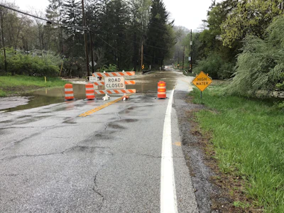

For years, a low-lying stretch of Riverview Road in Brecksville, Ohio, had a predictable problem when heavy rain arrived.
Water moving downhill through two tributaries to the Cuyahoga River would overwhelm stream crossings near the road. Sediment accumulated. The roadway flooded. Residents could lose access to their driveways, and at times the road had to be closed entirely, creating concerns about whether emergency vehicles could get through.
The Northeast Ohio Regional Sewer District (NEORSD) had been documenting the problem for years. Its stormwater inspectors monitored the area around major rain events, checking crossings for debris before storms and returning during and afterward to assess conditions.
"It was a hotspot that they would monitor for pre- and post-storm events," said Anne Schilling, watershed team leader for NEORSD.
Now, a $4.9-million project is changing how water moves through the area. Rather than relying on a single drainage improvement, NEORSD is raising a section of Riverview Road, replacing and enlarging two stream crossings, removing problematic sediment vaults and adding storm sewers for drainage relief.
The combination reflects a basic reality of stormwater engineering: Fixing a recurring flood problem requires understanding how the entire site behaves when the rain comes.
Designing around the water
 NEORSD
Water travels from higher ground toward the roadway before eventually entering the broad Cuyahoga River floodplain. Two tributaries must also pass underneath the road on their way downstream.
That meant engineers needed to understand both how much water was reaching the site and whether the existing infrastructure could move it through safely.
"There's a lot of local infrastructure as well as regional infrastructure," Schilling said. "Stormwater pipes: Where are those coming from? How much flow are those carrying from uphill to downhill? What's coming downstream through those tributaries underneath the road?"
Hydrologic and hydraulic modeling became central to the design. Engineers evaluated different storm events and considered what level of flood protection made sense from both safety and cost perspectives.
The project ultimately targeted a 100-year level of service, which Schilling said represents more than five inches of rain over 24 hours.
The modeling helped answer two fundamental design questions: How large did the stream crossings need to be, and how high did the roadway need to sit so that water could safely move beneath it?
The resulting solution is significant for NEORSD. Schilling said Riverview Road is the district's first flood reduction project to include raising a road, although several similar projects are now in development.
"There's no one-size-fits-all solution for our projects," she said.
When existing infrastructure becomes part of the problem
One particularly unusual piece of the project involved removing two sediment vaults.
The vaults had been installed as access points that allowed accumulated sediment to be removed from a culvert beneath the road. But the site's topography created an ongoing challenge.
Sediment eroded from stream banks upstream and traveled toward Riverview Road. As the grade flattened and stream velocity decreased, that sediment dropped out near the crossings.
During larger storm events, the infrastructure could no longer keep up.
"They were undersized for the types of storm events that we're seeing," Schilling said. "They would just surcharge, they would blow out, there'd be sediment and mud everywhere."
Eventually, the vaults had become more liability than solution. Removing them became part of the larger redesign.
The experience illustrates why flood mitigation projects sometimes require reconsidering existing assets rather than simply expanding or repairing them. At Riverview Road, larger crossings, additional drainage and a higher roadway elevation all had to work together.
A project years in the making
 NEORSD
Donna Friedman, manager of community watershed coordination at NEORSD, found correspondence about the project dating to the middle of 2020. Before design could move ahead, the district had to coordinate with the city of Brecksville, Cuyahoga Valley National Park and affected property owners.
The National Park Service was an important stakeholder because the tributaries ultimately discharge onto park property and into the Cuyahoga River floodplain. NEORSD also needed a permit from the park to perform portions of the work.
Two smaller projects were completed ahead of the main construction, including dredging at an upstream basin and additional dredging downstream on national park property to reduce sediment impacts.
Property and utility coordination added another layer.
Schilling said one lesson from the project is to address easements and property acquisition as early as possible. NEORSD discovered, for example, that it did not have stormwater easements over the sediment vaults that needed to be removed. Utility relocations also created scheduling challenges, including delays involving telephone poles.
"Looking at the property piece early on, if there's going to be any property acquisition components, who would be leading those conversations?" Schilling said. "It's helpful if cities have easements over their infrastructure from the get-go."
Brecksville contributed $900,000 toward the project through NEORSD's Community Cost-Share Program. Under the regional stormwater program, NEORSD returns 25% of the stormwater fees collected within a community to an account the municipality can use for eligible local stormwater projects.
Watching what happens when it rains
The project has now reached substantial completion, giving NEORSD an opportunity to see whether the redesigned system performs as intended.
The district isn't relying solely on visual inspections after major storms.
 NEORSD
Its Stormwater Inspection and Maintenance Department received permission from Brecksville to install a trail camera facing one of the new crossings near Greenhaven Parkway and Riverview Road. That allows staff to remotely observe how water moves beneath the roadway during wet-weather events.
NEORSD will also continue inspecting the project after construction. Inspectors visit completed stormwater projects twice a year, once during the growing season and once during the dormant season, to evaluate infrastructure, vegetation and overall performance.
"We don't just put them in and walk away," Schilling said.
For Riverview Road, that monitoring will help determine whether years of planning and a combination of relatively straightforward infrastructure changes have solved a persistent problem.
The project may be NEORSD's first road-raising effort, but it likely won't be its last. The district already has other flood reduction projects incorporating roadway changes in development.
For communities facing similar recurring flooding, Riverview Road offers a practical lesson: sometimes the solution isn't simply a bigger pipe or culvert. It starts with understanding where the water wants to go, then designing the road and drainage infrastructure to let it get there safely.