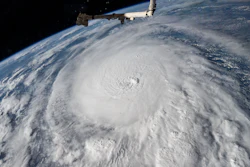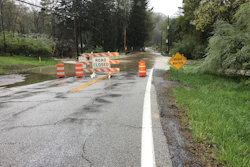

In August, parts of Indiana experienced a 1,000-year rain event that resulted in a 100-year flooding event. On the eleventh, a severe thunderstorm crossed into the state, creating straight-line winds, tornadoes, hail, and flash flooding. Some cities received up to 8 inches of rain in a 24-hour period and more than 11 inches within 48 hours.
The flooding hit Eastern Indiana cities the hardest. Carmel felt the effects, but not because it sat at the storm’s center—the flooding came from heavy rainfall upstream, in the cities surrounding it. The true epicenter was 55 miles away, in the Upper Reaches of the White River Watershed. Lane Young, Carmel Utilities Director
“Three different watersheds took that major rain event and distributed it three ways,” says Lane Young, Carmel’s utilities director. “Had the epicenter been a couple miles farther one way, a significant amount of more water would have come to those receiving streams.”
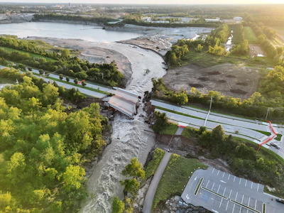
While Carmel has invested in resilient water infrastructure, a levee separating Blue Woods Creek from a deep quarry pit was not equipped to handle the flooding caused by 11+ inches of rain falling in 48 hours. The levee breached and Blue Woods Creek began flowing backwards into the pit. The sheer force of this backflow caused the levee to fail and the 4 lane Hazel Dell Bridge to washout in a matter of hours.
The city had to act fast, and the on-the-fly decision it made was unique, innovative, and effective: a manmade dam made from concrete and sycamore trees.
 A closer look at the Hazel Dell Bridge washout. | Photo by the city of Carmel
The Engineering Decision Behind the Dam
The city met with the Army Corps of Engineers as well as various state and federal agencies, who determined that due to the volume and velocity of water, nothing could be done at the time to stop the backflow.
Carmel’s Engineering and Stormwater team looked closely at LIDAR elevation data on the city’s GIS map viewer to better understand what was happening. There was concern that rainwater was filling the quarry faster than the White River could recede and overtop one of the City’s major roadways—96th Street or Gray Road. Using a digital elevation model of the quarry they determined the water would not crest over the roadways if the quarry filled.
“There was going to be an equalization point when all of a sudden we would have to reverse the flow of the White River into the quarry until it hit that elevation and went back,” Young says. John Thomas, Carmel Stormwater Manager
“We thought we were in the clear and that we could go to bed,” adds John Thomas, Carmel’s Stormwater Manager. “We have some extra flooding storage, and the agencies told us there’s nothing we can do.”
That reassurance didn’t last. The next day, Thomas got another call from the city engineer, Bradley Pease: a waterfall had eroded 250 feet back from the quarry that was about 20 and 30 feet deep, and it was only a few hundred more feet away from the city’s infrastructure. Two force mains, a 36-inch and 20-inch pipe that carry about 90% of the flow from the lift station to the treatment plant down south, were suddenly compromised.
“The bigger concern is what would happen if the waterfall reached all the way back to the river,” Young says. “If that happened, a large part of the river would’ve been directed our way, creating a whole other bit of havoc.”
Officials warned that any material placed in the water would get swept away by the current, but the team wasn’t willing to stand by.
“I wasn’t thrilled at being told we could do nothing to help,” says Matt Higginbotham, Carmel’s street commissioner. “We all had a hard time believing there wasn’t something we could do.”
 Black Hawk helicopters dropped sand bags into the river to create a second barrier. | Photo by the city of Carmel
Building the Dam
That frustration reached Mayor Sue Finkam directly. She pulled Higginbotham aside and gave him the greenlight to act, on one condition: everyone stayed safe. Matt Higginbotham, Carmel Street Commissioner
“Beavers stop rivers all the time, right? All we had to do was lower the flow rate to stop that erosion,” Higginbotham says.
Two trees had already fallen in the river at one location, so Higginbotham’s team built onto them. They felled more trees that the violently eroding creek would eventually claim, specifically large sycamores, to reinforce the barrier.
The next step was to fill in the gaps with crushed limestone from the nearby quarry to build dams. But a safety restriction kept the quarry from sending materials to the site, forcing the city to find a separate source: reclaimed concrete waste.
“It just so happens this reclaimed concrete is about the same size as shot rock, which is usually 2- to 3-foot chunks of crushed limestone,” Thomas adds. “It was the type of material we wanted, and it was about the only material available to haul in our trucks.”
Crews started building on Monday afternoon, right after the meeting with the mayor, and worked for three days straight. Through it all, no one knew if the first dam would hold or not.
“We finally connected the trees all the way across the river between 5 and 5:30 Wednesday morning,” Higginbotham says. “We weren’t sure what was going to happen after that. There was still a large volume of water and the level of the river was still out of its banks. But it did hold.”
By Wednesday, Carmel’s dam was holding, but the danger wasn’t over. That same day, the National Guard arrived to extend the effort farther downstream, building a second barrier out of sandbags—dropped into the river by Black Hawk helicopters.
Carmel’s City Engineer worked directly with the pilots, ensuring each load landed where the current needed to be blocked. In addition to the first dam and the Guard-built sandbag dam, the city built four more barriers to protect its infrastructure.
But just how close did Carmel come to disaster?
What Would’ve Happened Without the Dams?
While it’s difficult to predict what exactly would’ve happened if the dams hadn’t been built, Young says the aftermath would have been catastrophic. If the river hadn’t been dammed when it was, the waterflow downstream would have slowed or dried up temporarily, then surged back all at once.
“There would have been three to four times the volume, which means other infrastructure in the area probably would have been destroyed,” he says. “Our lift station would have been destroyed, and we have an elevated well that probably would have been taken out.”
While the company that owns the quarry lost revenue after it was flooded, it saved Indianapolis and its neighboring cities from a much more destructive fate.
What Other Cities Can Learn From This
There’s one thing other cities can learn from Carmel’s experience above anything else: the importance of innovation and perseverance when facing an unprecedented situation.
“You have to be willing to try new things, adapt as conditions change, and keep moving forward,” Thomas says. “There were times when we didn’t have all the answers, but our team kept looking for solutions and finding ways to protect our infrastructure and our community.”
To improve in the future, more data will be valuable.
The team realized the limitations of prediction models when multiple rain events interact. The team looks forward to opportunities for more data to improve these models.
“Other river communities could be facing similar threats since many sand, gravel, and mining operations are located near them, and utilize levees,” Thomas adds. “That’s where the good material is due to prevalent glacial outwash.”
Most notably, he says, the neighborhoods that were most at risk during this flood were built in the 1970s, well before modern floodplains and detention regulations existed. The neighborhoods that had been proactively protected, however, were in a much better position.
“I think that’s shown the power of those regulations,” Thomas says. “We’re advancing city planning towards protecting those resources, because it’s not if, it’s when.”
For Carmel, that means treating this flood as a preview and building accordingly.